Explore
Arts & Culture
The next time you Wander Out Yonder, why not explore the inland arts and treasures on offer in the Wheatbelt?
Come and join us in celebrating the unique arts and cultural offerings this amazing region has to offer.
Beverley Station Arts and Platform Theatre
Located in the centre of Beverley, the Station Gallery and Platform Theatre is the heart of the Arts community in the town. The Station Gallery is home to the Shire of Beverley community art collection.
An Artist in Residence program runs from the old station masters residence, culminating in several Exhibitions each year. Open Thursday to Sunday, 11am – 3pm. *Closed through the month of January
More information –
120 Vincent Street Beverley
Mobile: 0419 040 063
East End Gallery
The East End Gallery is home to a vast collection of artwork, including paintings and sculptures; most of the work on display is for sale. Owners Kate and Michael are passionate about supporting and promoting the works of Wheatbelt and Western Australian artists. You will also find on coffee locally made jewellery, craft and clothing.
The gallery is open Thursday to Sunday 11am to 5pm or by appointment and open public holidays.
More information –
116 Vincent Street Beverley
Kate – 0414 255 781
Michael – 0400 373 822
Kelly D Pottery Studio
Create your own unique ceramic pottery. Kelly offers individual studio session as well as themed group workshops.
R Luck Design & Marion Luck Art
A lovely studio of creative arts with Rebecca’s jewellery designed and made here in Beverley, and Marion offering art lessons and workshops. Art and jewellery for sale.
Mandy's Art Garden
Check out Mandy’s purpose-built workshop space on Vincent Street or enrol in one of her latest art workshops at the Art Garden.
Street Murals
Enjoy a walk around town and admire the Shire of Beverley’s commissioned murals painted by artist James Giddy. The five murals are located amongst the buildings in Vincent Street.
James Giddy’s work is inspired by the natural environment, which is a perfect fit in Beverley’s streets-cape.
Dead Finish Museum
As the oldest building in Beverley, the “Wheatsheaf Inn” was build by Alfred Smith in 1872. It now houses a very fine collection of artifacts depicting life in Beverley since settlement in 1831. Open every Sunday from 11am to 3pm from mid-March to November and at any other time requested.
More information-
Cnr Hunt Road and Morrison Street
PO Box 182, Beverley WA 6304
To open up please call
Joy 0427 411 881 or Delys 9646 1075
Avondale Machinery Museum
The Avondale Agricultural Museum Collection is located at Avondale Farm a 710ha property, located 6km west of Beverley. The collection was comprised of items donated by farmers from around the State for the sesquicentenary celebrations in 1979. The exhibition concentrated on items of technological significance, much of which was restored by the Department of Agriculture’s workshop. The collection was specifically put together to represent the historical equipment of all the processes in agricultural production, and therefore tells the story of the development of farming in the Western Australian Wheatbelt.
More Information –
550 Waterhatch Road Beverley
Avondale Machinery Museum
Barry and Kath Ferguson operate this private display of vintage machinery and appliances from days gone by. The display is also home to a very impressive vehicle registration plate collection, and various items of local significance. Open most weekends or by appointment.
More information –
22 Hunt Road Beverley
Phone: (08) 9646 1034
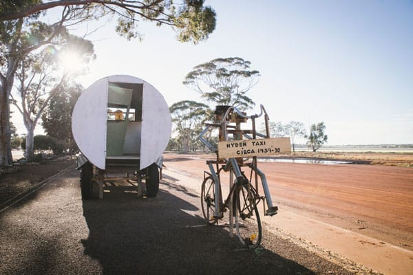
Aeronautical Display - Beverley Visitor Centre
The Silver Centenary is a biplane which was built in Beverley between 1929 and 1930 by a local named Selby Ford. Plans for the plane, which was named in honour of Western Australia’s 1929 centenary, were drawn to scale on the floor of the Beverley powerhouse which Ford owned. The aircraft made its inaugural flight on 1 July 1930 and was flown for the next 18 months, but after Ford proved unable to provide the authorities with blue prints and technical specifications, it was mothballed in 1933.
There is a wonderful interactive display, complete with a 1:5 scale model, exact replica of the silver centenary plane built in Beverley.
More information
Beverley Visitor Centre
141 Vincent Street Beverley
Phone: (08) 9646 1555
Open 7 days
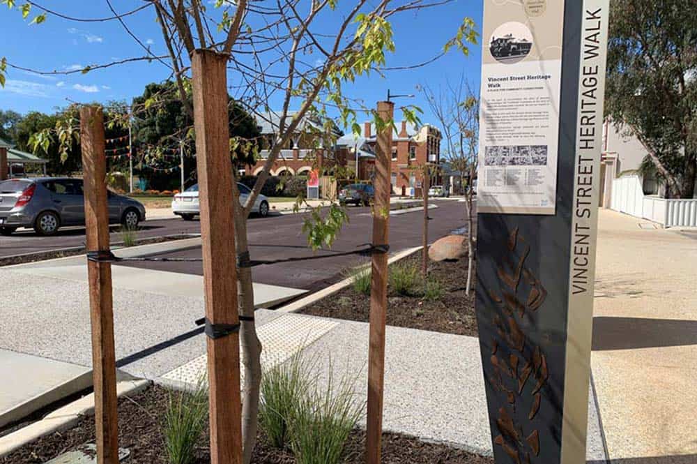
Vincent Street Heritage Walk
This award-winning trail guides you on a tour of the stunning heritage buildings in Beverley. Download the app by scanning the QR code at the trail head just outside the Beverley Visitor Centre. As you walk along Vincent Street pedestals will be found outside the buildings of significance or follow the map on the Augmented app reality app. Each identified place has cultural significance to the Beverley community.
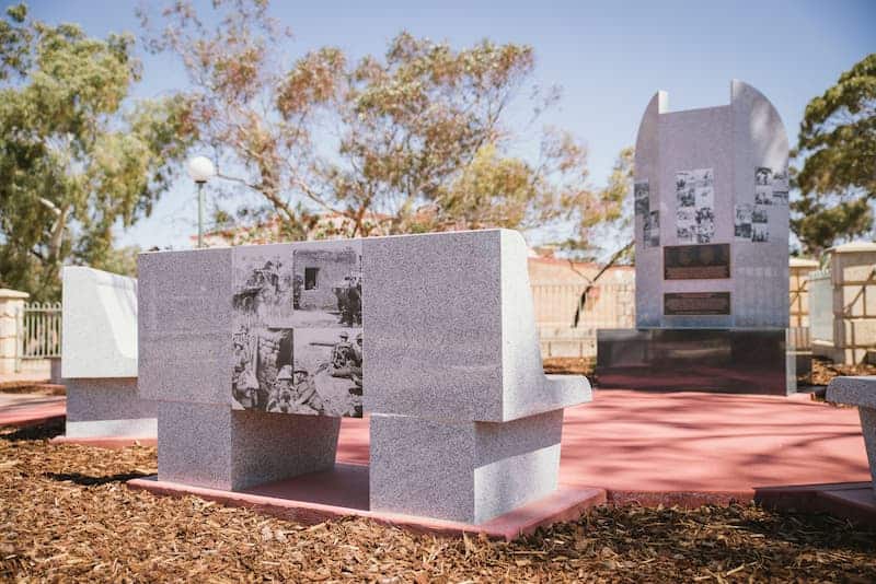
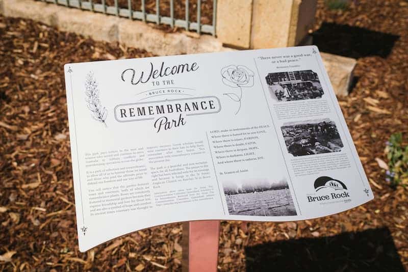
Bruce Rock Remembrance Park
The Bruce Rock Remembrance Park is located in the main street, Johnson Street, Bruce Rock -opposite the Shire Administration Building.
Officially opened 6th November 2021, this park pays tribute to the men and women who served, and continue to serve Australia in military conflicts and peacekeeping operations across the globe.
The Park features 11 specific memorials accompanied by information boards outlining the story and meaning behind each memorial. There are also eight sculptures and artworks featured throughout the park, all interpretations of the theme ‘war and peace’, with the highlight being a. replica peace window from the Bruce Rock St Peters Church. The Peace Window was the first stained glass window in Australia dedicated to Vietnam Veterans. The window was a project of the Bruce Rock Veterans Group, and was installed during the inaugural Back to the Bush Veterans Reunion in 2001.
All of this is set amongst gardens, walk paths, seating, and a gazebo in the centre for people to rest, reflect, and remember those we loved and those who paid the ultimate price to defend our freedom and our way of life.
The park is a peaceful and non-sectarian space, for all Australians. Whether during the day or at night when the park is beautifully lit, we encourage locals and visitors to our town to visit the Bruce Rock Remembrance Park as a place of significance and reflection.
Bruce Rock Federation Amphitheatre
Officially opened on October 2001, the Amphitheatre seats up to 1200 people. Designed and built by the local community, it is the host for many get-togethers and community events including the annual Vietnam Veterans Reunion and many other shows, concerts and community initiatives.
Contact: Bruce Rock Shire Office on (08) 9061 1377
Bruce Rock Centenary Mosaic Pathway
The mosaic pathway was created in celebration of Bruce Rock’s centenary celebrations in 2013. The pathway contains over 300 mosaic slabs which depict farms, buildings, churches, sporting groups, shops and families of the Bruce Rock district from days gone by.
A information booklet and pathway guide containing an explanation of each slab can be purchased at the Bruce Rock Community Resource Centre.
Shackleton Bank
The Bankwest bank at Shackleton claims to be Australia’s smallest bank. This is a claim that few would argue with. Measuring only 3 metres by 4 metres the bank closed its doors from business for the last time in 1997.
Throughout its life, the building has been an Aircraft Observation Post during World War II, a Child Care Centre and the Bank of New South Wales before it finally became known as Bankwest.
Bruce Rock Museum and Machinery Museum
The Bruce Rock Museum is located on Johnson Street, and contains a comprehensive collection of memorabilia. To the rear of the museum you will find an original one-room school house and a replica mud brick settler’s cottage from pioneering farm days.
Situated across the road is the Machinery and Motor Museum, which houses working farm machinery, a vintage car and a steam traction engine – all from local historical times.
Come in and have a chat with our friendly volunteers in the Museum, and learn about the history of our town.
Opening Times:
When the flag is on display. Please contact the Bruce Rock CRC for further information 9061 1687.
Dog Cemetery
Established in 1974, the Dog Cemetery is a tribute to Man’s Best Friend. With over 200 loved ones now buried, the cemetery is unique to Corrigin and worth a visit. Take time to read some of the headstones of beloved pets in their final resting place.
Located 5kms west of town on the Brookton Highway, the Cemetery is landmarked by a statue of a large dog. Any person is welcome to bury their dog at the cemetery, although contact with the Shire office must be made first. Call the office on (08) 9063 2203 during business hours.
Corrigin Pioneer Museum
Housing the history of our days gone by, a worthwhile visit whilst in Corrigin. View the collection of tools and restored farm machinery, including tractors in working order, see the blacksmiths shop, the one room school, the shearing shed, old district photographs, clothing and other pioneer memorabilia. The Pioneer Memorial Wall at the entrance to the Museum commemorates early settlers. Please call in for a visit, you will be surprised!
Cost: Adults $5, Children Free (accompanied by an Adult), Unaccompanied Children: $0.50
Opening Hours: Sundays 2pm – 5pm and Wednesday 1pm – 4pm
Contact: Eric Jespersen – (08) 9063 2930 or Peter Tulloch – (08) 9063 2225
Mallee Tree Cafe & Gallery
Located in the town centre, this quaint little cafe offers tea & coffee, cappuccinos, lattes, lunches and special treats. It is also part of a business that uses mallee trees to make various arts & crafts which are displayed in the gallery.
Address: Campbell Street, Corrigin WA
Opening Hours: Monday to Friday 8:30am – 5:00pm. Saturday 8:30am – 1:00pm. Closed Sunday.
Phone: 08 9063 2384
Agricultural Show Mural
The history of the Corrigin Agricultural Show has been encapsulated in time by this inspiring mural, created by local artist Sonia Price. The mural portrays key moments from the show’s history, such as its inception, notable competitions, and the evolution of agricultural practices over the years. It serves as a focal point for both locals and visitors alike, inviting them to reflect on the traditions and values that have shaped the Corrigin Agricultural Show into the beloved event it is today. This event is located on Kirkwood Street.
Scenic Lookouts
RSL Lookout and the Scenic Drive Lookout, provide ideal photo opportunities of the various views including the town site, salmon gums, wheat fields and natural bush reserves. You can also inspect the World War I Turkish Mountain Gun located at the RSL Lookout.
Miss B's Park
Located in the heart of town, this is the perfect picnic, BBQ and rest spot with landscaped garden surroundings, shade, toilets and play equipment for the kids.
Adventure Playground
A great place to picnic with playground equipment for the children. Located next to Corrigin Rock, the Adventure Playground provides plenty of shade and tranquillity. This park has a fort structure (which is also disability accessible) and a ‘spider net’ to climb and play on. A gas BBQ, picnic setting, toilets and shelter have been installed with paving all around.
Rotary Tourist Park
Situated next to the Pioneer Museum, Rotary Park is the perfect picnic spot with toilets, gas barbecue, shaded tables, green grass and play equipment for the kids and is conveniently located next to the Museum.
Corrigin Nature Reserve
At 1200 ha in size, the Corrigin Nature Reserve is one of the largest and most important areas of remnant vegetation in the central Wheatbelt. The Scenic Lookout and Wildflower Drive are located in the Nature Reserve, located 5km out of the town site on Brookton Hwy heading to Perth (signposted) and is one of the best locations to seek out wonderful wildflowers and native vegetation, however you will also be lucky enough to see them in the road verges and reserves throughout the whole shire.
Gorge Rock
Located 20kms from town, Gorge Rock is a natural rock pool which was once the local swimming hole (before the Olympic pool was constructed in town). A walk to the top offers spectacular panoramic views of the Corrigin countryside and the area provides a good rest stop for travellers with parking and picnic facilities. Many native animals and birds inhabit the surrounding natural bushland.
Corrigin Wildflower Drive
Like most rural areas, Corrigin experiences some beautiful sights during the wildflower season, which is usually in September / October every year. The Corrigin Wildflower Drive starts opposite the Dog Cemetery, 5km west on the Brookton Highway and takes you on a well maintained gravel track to the Scenic Lookout, which overlooks the town site and wheat bins. Variety is the keynote as the plants change with soils through woodlands, thickets and shrub land. For further information view the Corrigin Wildflower Drive brochure or call into the Corrigin Community Resource Centre at 55 Larke Crescent, Corrigin.
Corrigin Walk Trails
Whether stopping to break your journey or staying a while, Corrigin offers a variety of interesting tracks and trails. From a gentle stroll around the Shopping District Route to an exhilarating scramble on the Corrigin Rock Trail, we have something for everyone!
View the Corrigin Walk Trails map or call into the Corrigin Community Resource Centre at 55 Larke Crescent, Corrigin to pick-up a brochure.
Bird Watching
Experience a wide range of bird life within the Shire of Corrigin and surrounding areas.
For a guide to Bird Watching sites, download the ‘Birdwatching Around Corrigin‘ brochure
Hyden Art Trail
The art trail in Hyden recognises and celebrates the creativity of the residents across Hyden. There are heaps of different types of artwork from sculptures to murals.
Sculptures are made from old machinery, implements, and scrap metal that tell the history of Hyden, from early times prior to settlement, through to the first tourists in the 1970s.
The sculptures can be found to the right along the main street in Hyden.
Pioneer Town
The Pioneer Town Museum is located at the Wave Rock kiosk at the base of Wave Rock.
The Pioneer Town Museum features a variety of site-specific displays, including a general store (complete with old grocery items), pipes, tobacco tins, cameras and veterinary instruments from the 1930s, a bar from the German Embassy in Fremantle, a kitchen display from the 1900s, and a bottle collection dating back to 1870.
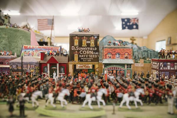
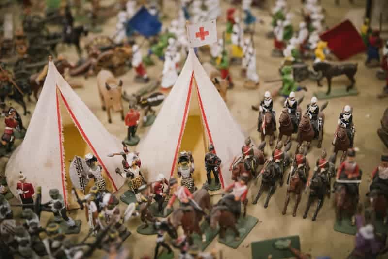
The Toy Solider Museum
The toy solider collection was previously owned by Alex Smith who amassed 10,000 toy soldiers over 60 years in displays depicting battles fought over hundreds of years.
Art Trail
This fabulous public art trail recognises and celebrates the creativity of local residents across the Shire of Kondinin. Come and take a walk around the townsites of Kondinin, Karlgarin and Hyden to view the array of sculptures, murals and mosaic pieces.
For further information call the friendly staff at the Shire of Kondinin on 08 9889 1006.
Spinel - by Jo Mc Designs
Jo Mc Designs is a small business based in Kondinin in the Wheatbelt region of Western Australia. It was founded in late 2017 by self taught artist Jo McCubbing. Jo’s collection of designs is named Spinel after one of the August birth stones. This precious gem stone can be found in a range of dazzling colours from deep reds, pinks, greens, black and blues. It reportedly has calming and healing properties.
Jo’s love of nature, plants, Australian landscapes and environmental patterns are reflected in her vibrant paintings and designs. Her works are unique and original limited prints. Painting with acrylics and inks has been a healing process after what Jo refers to as ‘burn out’, but was in reality years of living with anxiety. Her use of vibrant colours coined the phrase ‘adding colour to your life’.
The designs are digitally printed in Australia onto quality fabrics. They are machine sewn and packed personally by Jo. At times if stock is low, orders may take 2-3 weeks from time of order, to production and shipping. Please be patient as this allows the necessary time for your piece to be lovingly created.
These handcrafted scarves and wraps are lovingly created in Australia and Jo’s designs accessorize and add colourful luxury to your life. View the full range and shop online at: wwww.jomcdesigns.com.au
Phone: 0428 104 150
Art Show & Twilight Markets
Early October – The Annual Kondinin Art Show draws artistic creations from all over WA and provides a great weekend getaway paired with a local Twilight Markets at the town’s Community Garden.
Kondinin Bush Walk
Natural woodland covering over 50 hectares.
Kondinin Lake
Great for water skiing and windsurfing when full. Perfect spot to view waterbirds.
JS Roe Heritage Trail
Includes a mural of the JS Roe Expedition of 1848-49, Kondinin Well and Yeerakine Rock.
Woorkakanin Rock
Once used as a water supply for steam trains at Kondinin Railway Station and now part of the 18 hole Kondinin Golf Course.
Yeerakine Rock
Located 12km east of Kondinin offering shady picnic areas, two walk trails with interpretive signage and 360 degree views from the summit. Yeerakine Rock is also a great place to view wildflowers each September and October. The best time to view the inspiring Light Horse memorial is during Kondinin’s dawn ANZAC Day service.
Kondinin Centenary Walk and Pioneer Wall
Located in the centre of Kondinin, next to the caravan park, have a look at the map and list of families who first came and settled farm blocks in the Kondinin district and stroll along the mosaic pathway and marvel at the collection of Ironman sculptures all built in 2010 to celebrate the town’s centenary. Venture down to the sporting precinct to view the life size sporting sculptures created by local community members.
Kondinin Community Garden
Located at the former location of the old swimming pool, the area has been transformed into a fantastic public place. Have a look at the murals painted as part of a community art project, the array of veggies that can be picked for a donation and the nature play area complete with Nyoongar six seasons and a Mia Mia. This area also has seating and public toilets.
Kulin Community Arts
Kulin Community Arts is located on High Street next to the Tyre Service. Community Arts is run every Friday from 10.00am – 3.00pm and all are welcome.
Entry: $5 per visit
Phone: 0429 809 013
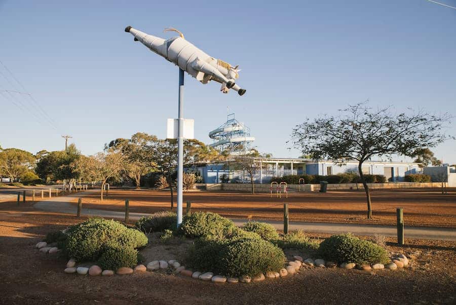
Tin Horse Highway
The dusty paddocks surrounding Kulin have become a gallery of bright, quirky, community creations. What started as an authentic community marketing campaign to promote the annual Kulin Bush Races has become one of Western Australia’s most popular self-drives.
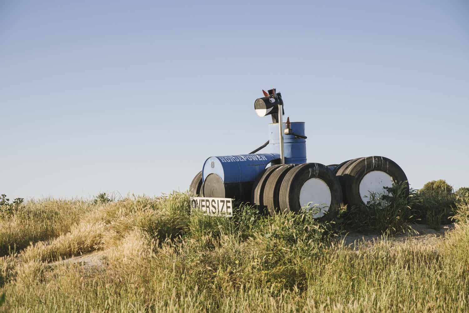
The Tin Horse Highway provides a seriously entertaining drive and a fun alternative route to iconic Wave Rock. The Tin Horse Highway is free and open all year round.
Where is Tin Horse Highway
Download the Tin Horse Highway Map HERE
The Tin Horse ‘Highway’ is a 15 kilometre stretch of road in Western Australia which heads east from the town of Kulin out to the Kulin Bush Races Track at Jilakin Rock. The roads official name is the Gorge Rock -Lake Grace Road.
Whilst the majority of tin horses are found on the Tin Horse Highway, you will also find many equally impressive and imaginative tin horses along other roads in the Kulin Shire and in Kulin town. All tin horses in the region contribute to the Tin Horse Highway story and reflect the vibrant, good humoured community who have built them. There are currently over 70 tin horses displayed on the Tin Horse Highway, in the town site of Kulin and along other roads to Kulin.
West Kulin Horses
On the west side of town you will also find a herd of terrific tin horses including the BIGGEST tin horse in the region! The ‘West Kulin Whoppa’ is a reflection of many years of friendly competition between East and West Kulin farmers.
Much more than metal
For nearly two decades, the crazy tin horses of Kulin have entertained travellers driving the Tin Horse Highway. Since 1995, tin horses have been popping up along the highway, in town and on other roads in the region. But there is more to these terrific bits of tin than meets the eye. Behind every quirky steed is a person with an inspiration, a story and a memory. Kulin’s Tin Horse Highway is so much more than metal.
Tin Horse Highway Short Documentary
Featuring a selection of local tin horse ‘artists’ in their ‘studios’ (studios being farm workshops, scrap heaps, sheds and on the Tin Horse Highway itself) this short film captures the uniqueness of the Tin Horse Highway and its significance to the Kulin community. Take a look here
Tin Horse Highway Souvenir Book
Take home a souvenir to remind you of your adventures along the Tin Horse Highway. The Shire of Kulin and community have a book entitled ‘Much More than Metal’. This collection of short stories takes an in-depth look at the Tin Horse Highway, its stories, history and community.
Copies of ‘Much More Than Metal’ are available for $10.00 at the Kulin Community Resource Centre. Orders can be made over the phone by calling the Shire of Kulin on 08 9880 1204
Kulin Bush Races
Get ready for a weekend of events, activities, live bands, family entertainment, delicious food and a Sunday morning breakfast not to be missed! This iconic ticketed event held over the first weekend in October, attracts around 4,000 patrons from across the country.
Macrocarpa Walk Trail
The sheep and grain-farming districts surrounding Kulin provide spectacular wildflower displays in season (Sept – Dec). The flowering gum, Eucalyptus macrocarpa, is the town’s floral emblem and can be viewed along this brilliant walk trail, located only 1 kilometre west of Kulin.
Make sure you download a copy of the new Macrocarpa Walk Trail brochure to take with you on your walk.
Discovery Zone
Get a sense of Kulin’s history and identity uniquely and informally by enjoying the Discovery Zone which contains information points, interpretive signage, and artwork. This Discovery Zone has the following amenities:
- War Memorial
- Town Centre Park and Stage
- RV Friendly 72 Hour parking & Dump Ezy Point
- Public Toilets and Showers
- Picnic Shelters and BBQ
- Rehabilitated creeks
- Playground
- Extensive landscaping – planting, paths, boardwalks and lawn areas.
- Skate Park
Giant Water Slide and Aquatic Centre
The biggest water slide in regional WA! At 182m long and 18m high, the Kulin Water Slide provides hours of endless summer fun and excitement for people of all ages. For a more relaxing experience, cool off in our brand new swimming pool. Facilities include a 25m lap pool, learn to swim pool, beach entry, tiny tots pool, BBQ’s and half-court basketball.
The Aquatic Centre and Water Slide are open in the summer months. For any enquiries please contact the Pool and Slide Manager during pool opening hours.
Contact: Pool and Slide Manager: Mark Gillbard
Phone: (08) 9880 1222 (during pool opening hours)
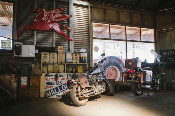
Butler’s Garage (Kulin Museum)
Built in the mid-1920s, Butlers Garage operated in Kulin until 1994. Today it has been restored and houses the Kulin Museum. The museum contains an impressive collection of vintage cars, farm equipment and machinery.
The Museum is open Wednesday and Saturday 10am – 2pm, and by request. Call 9880 1024 to arrange a visit.
Jilakin Lake and Rock (No Camping)
15 kilometres east of Kulin is the spectacular grey monolith, Jilakin Rock. An easy climb to the top of the rock provides spectacular views of Jilakin Lake and the surrounding Wheatbelt. At its base, you will find a shady picnic spot. Jilakin Rock also boasts the most isolated known stand of jarrah (150 kilometres from the main jarrah belt), surviving on the water runoff and quarry soils at the base of the rock. Camping is NOT permitted at Jilakin Rock and facilities here are for picnics only. Kulin town welcomes fully self-contained travellers to use our fantastic 72 HR RV Friendly Camping Area located on our main street.
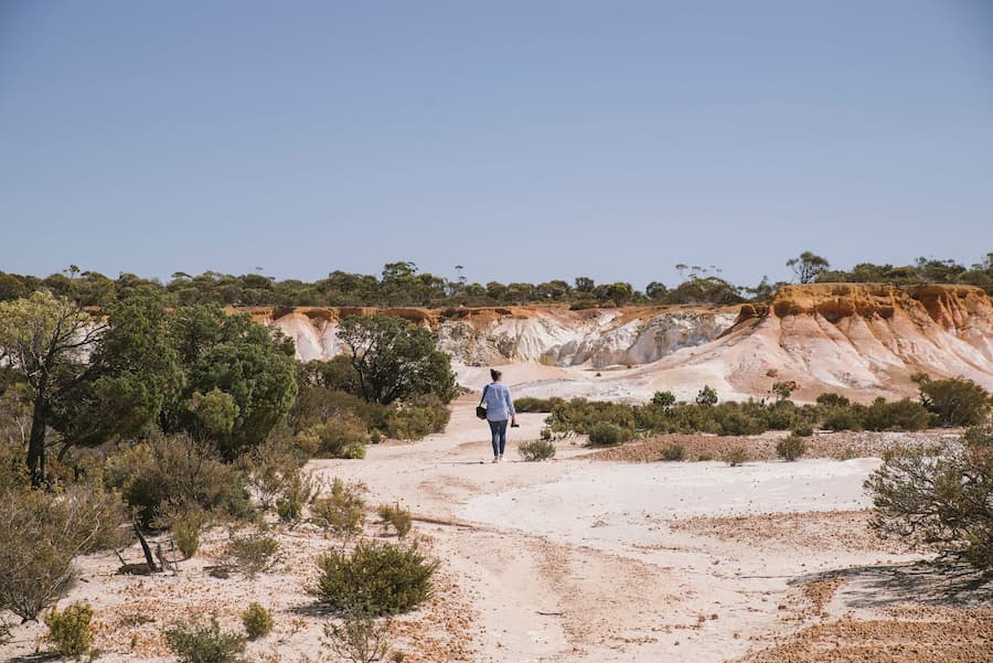
Buckley’s Breakaway
Located 70 kilometres east of Kulin, off the Holt Rock Road on route to Wave Rock, Buckley’s Breakaway is a picturesque landform where erosion has cut through the orange laterite and formed spectacular white cliffs and gullies from the underlying clay. The gully is dominated by Cypress Pine, Blue Mallet and Box Poison, but it is the top of the “breakaway” which carries the most interesting plants. Look for delicate orchids, trigger plants and sundews. At the site you will find interpretive information about the area, a fabulous picnic spot and endless photo opportunities!
Varley Rabbit Cemetery
The small township of Varley is in the Lake Grace Shire. This memorial was erected by the local community in memory of all of the rabbits who lost thier lives at the Rabbit Proof Fence. The rabbit proof fence consists of three fences erected in 1902 to keep rabbits out of WA. The fence is the longest fence in the world, totalling a distance of 3,236.8 kms.
Lake Grace Regional Art Space
Drop into the Lake Grace Regional Artspace and immerse yourself in creativity with the current major exhibition or view quality regional art in the window box display. Admire and purchase orginal artworks for your family and friends from our artists gift shop. Have a chat with interesting local artists and members of the Lake Grace Artists Group each Tuesday or join in and learn some secrets with an art expereince workshop. Located on the Main Street in Lake Grace next to the Visitor Centre. Open Daily 10am – 4pm during exhibitions, to find out whats going on follow us on Facebook or visit our website!
Lake Grace Story Trail
Follow a rich collection of stories to discover the heritage of the local community. Plaques are displayed in the sidewalk on the main street in the town of Lake Grace. Call into the Visitors Centre for a map.
Pioneering Woman Mural
A mural inspired by the women pioneers of the district—from European settlement to present. Featuring 48 remarkable women from rural Western Australia. These are the women who built their communities and transformed local politics, who worked in the home and in the paddock, who spoke out and acted up. Stories and profiles are published from local author Michelle Slarke in her book Farsite, available for purchase through the Lake Grace Visitor Centre. The Mural is located on the main street in Lake Grace opposite the Visitor Centre and facing the war memorial.
Mosaic Garden Gallery
The mosaic garden gallery features 365 colourful mosaics that reflect the lives of past and present community members. Located next to the medical centre in Lake Grace up Memorial Drive.
AIM Penny Pathway
Follow a short pathway (50m) of commemorative plaques from Apex Park to the AIM Museum. Located on the edge of town on Stubbs Street heading towards Dumbleyung.
Australian Inland Mission Hospital Museum
One of three remaining Australian Inland Mission Hospitals, and the only one in WA, this museum will take you back to some old style medical wards and artefacts. Walk through the old style wards, duty room, kitchen and laundry to expereince the atmosphere of an early twentieth century rural hospital. OPEN by appointment, call into the Lake Grace Visitor Centre for more information or use the phone located on the front veranda.
Varley Museum
Exhibits from the 1920s and also a tourist information point is found in the Varly Store, the town has a comphrehensive museum with displays of memorabilia and town records. Hatters Hill, Rabbit Cemetery. Contact the Varley Store on 08 9875 1200
Lake King Bush Engineers Museum
A display of local farm tractors that have been modified to suit the farm & conditions.
Salt Lakes
Lake Grace, Lake Bryde, Lake Biddy, Lake King. Geologically the Wheatbelt is an ancient stable area with a very low drainage profile. The rain that falls is very slow to drain away and is held in large shallow depressions. This leads to lots of evaporation and and the formation of lakes of salt. Unless the rainfall is very heavy over a number of seasons many of the salt lakes are dry for most of the year. Even in their dry state they offer stunning scenery and great photo opportunities.
Granite Outcrops
Dragon Rock, Dingo Rock, DIckman Rock, Namma Rock. Granite Outcrops are either inselbergs (isolated rock hills and knobs) or monoliths, (a single massive stone hill or rock). Erosion usually exposes these geological formations, which are often made out of very hard and solid metamorphic or igneous rock made from granite. Rising abruptly from the gently sloping or level surrounding plain they dominate the bushland.
Lake King Walk Trails
The Lake King Walk Trails have been provided for the enjoyment of locals and visitors who wish to undertake short walks and enjoy local wildflowers, native vegetation and a little history.
There are four walking trails to choose from – so take your pick. Produced by The Lake King Progress Association, the brochure includes information about the trails, a map, key of local flora and fauna and a description of the four different walk trails. Download the brochure here.
Grain Discovery Centre
Adjacent to the Narembeen Roadhouse (entry through the Roadhouse) is a modern, interpretive centre focusing on grain growing in Western Australia. Learn more about farming in Narembeen as you wander through the centre. Browse at the brilliant visual and interpretive displays as you discover some of the history and future of grain growing in Narembeen. Exhibits include a 1950s farm house kitchen, a ‘humpy’, a grain stack, an interactive CBH area with weighbridge and hut, displays on the future of farming and a supermarket showing end products, like breakfast cereals and bread. The centre also has an interactive agribusiness section, an export area detailing the journey of grain from farm paddock to overseas markets and displays on the future of farming. The centre is open from 9am to 5pm daily. Entry is via Gold Coin Donation. Tours available upon request.
For further information contact the Narembeen Community Resource Centre:
Phone: (08) 9064 7055
The Narembeen Hawk
A trip to Narembeen wouldn’t be complete without a visit to see the Narembeen Hawk, sitting proudly at the entrance of the Narembeen Recreation Centre. The Narembeen Hawk was unveiled at the opening of the new Narembeen Recreation Centre in April 2016, designed and constructed by local artist Jordan Sprigg who creates unique sculptures from historically worn and recycled metal. The Hawk has an impressive 2.5m wingspan and includes 1,000 individually cut feathers, taking 260 hours to complete. The sculpture includes metal collected from around the district, with some metal dating back to the early settlers of Narembeen. The Shire of Narembeen is proud to showcase a local artist’s inspirational creation as a centrepiece to the Narembeen Recreation Centre.
Walker Lake – Walk Trails
Feeling energetic? If you’re staying in town, this is the perfect opportunity to see Narembeen nature at its best. Located to the south of the Narembeen townsite is a natural lake with abundant water in summer. Wander around the lake as you take in this majestic setting. The Walker Lake trail is 1.8km, for those more energetic walk the 2.2km Avoca Farm walk trail, enjoy the rural setting as you take in the old Avoca Homestead, Shearing Shed and machinery on display.
Community Shed
Located in the former Moppett’s Garage on Churchill Street is a unique shed that is occupied by different community groups specialising in art and craft, décor and giftware. Certainly worth a look, visitors are welcome on weekdays.
Hidden Hollow
Situated approximately 30kms east of Narembeen, along your Pathway to Wave Rock experience. Formally known as Mt Walker Rock, this is the perfect place for a picnic and to see many wildflowers and orchids during Spring (Sept to Dec). This granite outcrop also boasts a natural amphitheatre that has been carved out of the rock over years of weathering – it can be found walking from the car park along the trail. For the more energetic – the view from the summit offers spectacular views of the district. Take your time, read the plaques at the little dam and discover a piece of farming history.
Wakeman Ski Lake
Situated approximately 13kms east of the Narembeen townsite, this lake has undergone major volunteer work to harvest water back into the natural lake (water level is dependant upon seasonal rainfall). During the summer months, the lake is a hive of activity with ski boats and water pursuits popular with locals and visitors. This is a picturesque location, with abundant bird life. Before entering the lake with boats, please contact the Narembeen Community Resource Centre T: (08) 9064 7055 (business hours only) and provide boat insurance details.
Roe Dam
Located approximately 45km east of Narembeen is a 20 million gallon storage dam completed in 1971 which supplies the Mt Walker farming community. This is a bird watchers paradise! Take in the majestic eucalyptus with an under-story of bracken fern. Picnic area, toilets and BBQ’s are available in this tranquil setting. The friendly locals are often seen leaving piles of firewood.
Roe Lookout
Situated approximately 8kms from Narembeen and named after John Septimus Roe, Surveyor General who led an expedition eastwards from York in October 1836. A scenic drive takes you to the peak of this granite formation with magnificent panoramic views of the district – a photographer’s delight! There is limited vehicle access to the top of Roe Lookout, the steep incline is not suitable for caravans. Feel free to park at the bottom and take a leisurely walk to the top of the lookout.
For further information:- Narembeen Community Resource Centre T: (08) 9064 7055
St Paul’s Museum
Located on Longhurst St, the St Paul’s Museum was consecrated in 1929 and opened as a museum for the Historical Society in 1969. After restoration in 1999 it re-opened as a Church Museum. It is a memorial to the pioneer women of the Narembeen district.
History Museum
Located in the Old Road Board Building, near the Town Hall on Latham Road, this museum contains a visual history of the district and includes photographs of early pioneer farming practices. Family files are also kept here, it has proven to be a great source of information about our locals.
History & Machinery Museum
Located on Savage Street, this museum contains an interesting mix of photos and antiques from our pioneers. Browse through the outdoor machinery museum displaying old farm machinery and farming implements.
Old Prospector’s Trail
This short, self-drive tour starts west of Narembeen at Dayman Rd, follow the signs and be transported back to the early days when sandalwood cutters and gold prospectors travelled this trail in search of riches. Interpretive displays, old water wells, reconstructed prospector’s camp, prospector’s barrow, amazing scenic lookout and undisturbed landscapes are part of this must do short loop.The self-drive tour is 38km and is not suitable for caravans. The roads are subject to flooding, so please contact the Shire of Narembeen on (08) 9064 7308 for current road conditions.
Spotter’s Post/War Museum
Located on Longhurst Street next to the Shire of Narembeen administration office is the Spotter’s Post, built in 1942 for the purpose of spotting enemy aircraft during WWII. In 1945 the Narembeen branch of the Sailor’s, Soldier’s, Airmen and Nurse’s Father’s Association of WA met at the building. In 1946 the building was converted for use as an Infant Health Clinic. In more recent times the Narembeen Toy Library has utilised the building. In 2015, the Spotter’s Post was opened as a War Museum to celebrate the Centenary of ANZAC.
Rabbit Proof Fence – Gate 54
Located approximately 70kms east of Narembeen, the fence stretches from Port Hedland to Ravensthorpe, spanning a distance of 1,827km. It was originally erected between 1901 and 1907 to prevent invading rabbits and other vermin entering the grain growing region. Much of the fence has undergone maintenance and some of the original fence remains today. An interesting place to visit. For tours or further information: Narembeen Community Resource Centre T: (08) 9064 7055
Boot Mile Fence
As you travel on the Pathway to Wave Rock from Narembeen to Hyden, you will pass a quirky spectacle on the Mt Walker Road. More than 1000 odd shoes and boots hanging from a fence line. The collection of footwear stretches for more than 1km and finishes at an old pull-chain dunny (toilet). The unusual and colourful display has been put together by local semi-retired farmers Ross and Helen Fidge, who after a trip to the US, thought it would be an interesting sight for passing tourists.
Newdegate Heritage Walk Trail
Come and join us for a walk and discover the history of Newdegate, starting back at town settlement and arriving in the current day. This project formed part of the Newdegate Centenary Projects, completed in 2022.
A Newdegate Heritage Walk Trail Booklet is available for purchase from the Newdegate Historical Society.
Newdegate Hainsworth Museum
Featured in the Rock Out on the Pathways to Wave Rock Youtube clip the Hainsworth Building houses the Newdegate Pioneer Museum. The building operated as a general store from 1934 until 1972 and had several owners. This museum is a great example of early settler life in the area. OPEN by appointment.
El Toro
A life-size spanish bull, expertly sculpted from recycled metal parts by Narembeen’s Jordan Spigg, stands proudly in Quairading – currently outside the Town Hall. Resembling strength, passion and prosperity, he’s a sight to be behold and just one stop on Jordan Sprigg’s Art Trail across the state.
Luke O’Donohoe Mural
Adorning the eastern side of the Quairading co-op is striking mural, designed and painted by artist Luke O’Donohoe. Each element represents a different aspect of the community or landscape of Quairading, with interpretive signage explaining each. Check it out and tag your photos #quairading.
Nookaminnie Rock Nature Reserve and Rowlie Mellor Walk Trails
527 hectares of unique remnant vegetation where you can enjoy some of the most beautiful wildflowers the Wheatbelt has to offer. At the heart of the Reserve you will find Nookaminnie Rock, a large granite outcrop with magnificent views, a perfect platform to watch the Wheatbelt’s breathtaking sunsets. A display board at the entrance to the Reserve outlines the marked walking trails. Pick up a copy of our Nature Reserve Map from the Quairading CRC and Visitor Centre.
Toapin Weir
An easy breezy 8 kilometres north (and slightly west) of the Quairading town site. Climb to the top of the rock with the assistance railing and take in the picturesque views of the region. Toilet facilities, electric BBQ, shade and info boards can all be found in the car park. It is also a quaint, quiet overnight camping spot with immaculate skies for pristine star gazing.
Pink Lake
Pink Lake is regarded as a local phenomena. It is located 11 kilometres east of town on the Bruce Rock road and at certain times of the year the left side of the lake is a distinctive pink colour while the right side remains blue. Summer evaporation causes the water level to drop and salt builds up on the old trees and fence posts. When the water returns, the salt causes the pink colour.
Lake Mears
This little known local gem is located partly within the Lake Mears Nature Reserve. Well worth a look, especially after heavy rainfall, to see it in all its glory at full capacity. There are no rubbish facilities here so please leave no trace and take your waste with you. Entry is off of Lake Mears Road.
Rabbit Proof Fence
One of the longest fences in the world! (3237 kms) You can view two recreated examples of this historic feat along with some other fantastic local history displayed in a well-maintained gazebo approximately 20 min drive south of town on the Corrigin Road. This site also features information about the innovative Stacey Lamb Train.
Quairading Vintage Club
It’s all about camaraderie and assembling or restoring old stuff down at the Vintage Club. Cars, trucks, tractors, motors – you name it – they fix it! Vintage Club members meet for coffee and a chat most mornings about 9am. A monthly meeting is held on the second Saturday of the month.
War Memorial & Lone Pine
The original tree grew on a ridge above the beaches at Gallipoli. It was known as the Lone Pine because it was one of the last pines of any size left before being shot to pieces just above The Nek. A Victorian Sgt Keith McDowell picked up a pine cone and put it in his haversack. After sending it to his Aunt in Warrnambool, she grew 4 seedlings from it, one of which is now growing at the Melbourne Shrine of Remembrance. It is from this tree’s seeds that our tree has grown. It is a Brutian Pine and is doing very well. During 2015 other projects are coming into being as part of our War Memorial precinct and in readiness for Centenary of ANZAC Day ceremonies.
Old Railway Station Museum
Open most week day mornings with local info and know how. Wood sculptures by the late Ian Wills on display and a kettle that’s always on.
Anglican Church Labyrinth
This Chartres 11 ring Labyrinth was built by residents of our town for contemplation and quiet thoughts whilst wandering through. It is one of ten listed at WA locations around the state. 8 are located at public places including churches and two are private. You’re welcome to visit ours at the Anglican Church on Harris Street, Quairading.