Explore
Outdoor Adventure
If getting outside is your thing, then the Western Australian Wheatbelt is ready and waiting for you.
Discover the magic of ancient granite rocks, wide open spaces, nature based walking trails, stunning flora and fauna, and dark skies full of stars that need to be seen to be believed.
What’s not to love? Come and join us and take some time for an Outdoor Adventure to explore this amazing region.
Avon River
The Avon River flows right through town and there is a picnic area on the east side of the bridge. The Avon River flows 240 km from source to mouth, where it becomes the Swan River. It can be seen from the top of County Peak. There are bridges across the river at Edward’s Crossing, Mt Kokeby, as well as in town.
County Peak
About 35km from Beverley, County Peak was given its name when the first surveyors drew up the original counties for the Swan River colony in 1829. County Peak was the intersection of counties York, Howick, Grantham and Minto. The peak is also known as Mt Quajabin. Quajabin is derived from the Aboriginal word Quabin, which means ‘good camp’. The hike up to the top is relatively easy but be sure to take adequate water and keep a lookout for snakes.
All routes to County Peak are suitable for non-4WD vehicles, however the most direct route from Beverley is down Great Southern Hwy and left at Kokeby East Rd.
Please consider current weather conditions as some roads may be closed during high rainfall events.
Gliding
The Beverley Soaring Society is the largest gliding club in Western Australia. Book a flight, learn how to fly, or feel free to just visit to watch as the gliders are towed in the air.
For all information on flight bookings, prices, and membership visit the Beverley Soaring Society website.
Nature Reserves
The nature reserves in Beverley provide a range of different wildflowers throughout the year. The best opportunity to see wildflowers is from August to October.
Brooking Street Reserve is located within the townsite. View Map.
Poison Hill Reserve is a short drive east of Beverley. Located on the corner of Aiken Road and Morbinning Road. View Map.
Dale River Reserve is located around 20km from the townsite. A hotspot for native birds. View Map.
Yenyening Lakes
These large salt lakes are located approximately 32km south east of Beverley. Water from the Lockhart and Yilgarn Catchments flow through the Yenyening Lakes and into the Avon River from an area of 91,000 square kilometres.
Yenyening Lakes are a haven for birdlife and are also used for water sports.
Avondale Bush Reserve Walk Trail
Note: This trail is currently only accessible by appointment. Please contact National Trust of WA (08) 9321 6088.
The Bush Reserve Trail is marked with a total distance of 1.8km. No hiking experience is needed however a reasonable level of fitness is required. It is recommended to allow an hour to walk the loop. On the trail you will discover an abundance of flora and fauna.
Avondale Drive Trail
Note: This trail is currently only accessible by appointment. Please contact National Trust of WA (08) 9321 6088.
The Drive Trail at Avondale Farm is 5km, however this will take longer than you expect with a speed limit of 15kph and much to see. Just over halfway through the trail you will get to the Avondale Bush Reserve Trail, so jump out and stretch your legs for a walk through the Bush Reserve.
Brooking Street Bush Reserve Trails
The Brooking Street Bush Reserve trails are walking distance from the main street and just around the corner from the RV Park. The reserve is a small but bountiful Bush Reserve. The reserve has over 12 native orchid species of which many are seen from July – October. The hybrid pink fairy and cowslip orchid is a species that attracts many.
Turn right off Vincent St onto Brooking Street. Turn right onto the gravel track where parking is available in the reserve. Please do not park at the Water standpipe on Brooking St. View map
Christmas Tree Well Walk
The Christmas Tree Well Walk is a relatively easy walk that is about 12km in length. Ensure that you carry with you water and the essentials. There is a picnic area near the start of a walk trail which leads to the picturesque walk through Wandoo Bushland. Located 20km from the Westdale / Brookton Highway turnoff.
County Peak Trail
Currently there are no formal walk trails at the site. An accessible drive trail loops around the peak. For those that wish to hike to the summit, views at the top are breath-taking. From the peak seven Shires can be seen including Beverley, Brookton, Pingelly, Corrigin, Quairading, Kellerberrin and York and the expansive Yenyening Lakes system can be seen.
Dale River Reserve
A hidden gem in the Avon Valley. The Dale River reserve is located around 20km from the Beverley townsite off Westdale Road. Located along the Dale River the reserve is a biodiversity hotspot for birdlife and native vegetation. There are two relatively easy walk trails under 1km from the main pool site. The wildflower loop which is best to walk in August and September and a river walk. View map
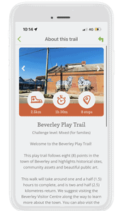
Beverley Play Trail
This is a fantastic trail for the whole family to enjoy! The walk will take around one and a half (1.5) hours to complete, and is two and a half (2.5) kilometres return. The play trail follows eight points in the town of Beverley and highlights historical sites, community assets and beautiful public art. We recommend parents remain with children to complete this trail as one of the stops requires users to cross a main road.
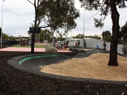
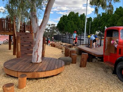
Moort Wabiny Park
here is something for the whole family to enjoy at Moort Wabiny Park. Complete with nature play, skate park, pump track, basketball court and shaded bbq area. Located in the main street next to all amenities and shops.
Geocache Trail - Wandoo Series & FOTT Go Bush
Not sure what geocaching is about? Go check out the Official Geocaching website. Beware…. you may get hooked! You will need to signup to be a member, however there is a whole new world ready to be explored.
The Wandoo Series is a trail that takes you through the Wandoo Bushlands from Karragullen to Beverley and York. This series of Geocache cover around 300km, but no need to do them all at once!
The FOTT Go Bush is a geoart trail that takes you on adventure through the Wandoo Bushland. Some preparation is required before tackling this trail. There are varying levels of terrain, some requiring 4WD.
Bruce’s Rock
Bruce’s Rock is a low granite outcrop which lies 2km to the east of the town. It was named after the sandalwood cutter John Rufus Bruce who set up his camp near a soak at the base of the rock. The rock is signposted to the east of the town. Cross over the railway line and take the Bruce Rock Rd until you see the green sign pointing to a dirt road heading north.
At the rock, there is a sign that reads:
“This marks the camp site of John Rufus Bruce after whom Bruce Rock was named. The small soak was originally a native soak, possibly centuries old. The deep well is a good example of the method used in stoning wells in the early 1900s by the Public Works Department.”
John Septimus Roe explored the area in 1836 but, like most of the Wheatbelt, it was not settled until after 1900, with land being released for agriculture in 1908. In the intervening years, the only people in the area were pastoralists, with large lease holdings who grazed sheep, and the occasional sandalwood cutter, such as John Rufus Bruce. John Rufus Bruce went on to become a coastal trader, owning his own barque, and with sandalwood forming part of his trade.
Kokerbin Rock
Known as Kokerbin Hill, it is the third largest monolith in Australia and is recognized as an interesting unspoilt spot for flora and fauna study. It covers 9 hectares and is 122m high with interesting formations, caves and a deep well on the western side. Situated approximately 40km north-west of Bruce Rock, the picnic and barbecue facilities that are available make to an ideal location for a pleasant outing with family and friends.
The Rock is situated within the Kokerbin Nature Reserve which is administered by the Department of Parks and wildlife. The picnic area is administered by the Shire of Bruce Rock.
DEC and the Shire of Bruce Rock are working to improve signage and walkways throughout the park. At present there are some roads closed and may cause some inconvenience, but these closures are in place to protect the cultural values, and the flora and fauna within the area.
There is a road around the base of the Rock. Parking areas there allow you to stop, and walk to the top for a view of a lifetime. The road will take you past such sites as the Well, and give you good views of Devils Marbles.
Kwolyin Campsite
Kwolyin Campsite is situated on what used to be the old football oval. You wouldn’t know it now though, as pristine bush with orchids, flowering annuals and sandalwoods surround the camp.
The camp boasts toilets, camp kitchen, large and small shelters, dedicated tent camping and caravan bays, campfires with BBQ plate (1st April – 30th September only), bush walks and a pioneer walk trail through the old campsite and more!
*There are no camping fees, and bookings are not required.
Granite Way
From Kwolyin, strike out on a 60km tour of the most impressive granite rocks on any drive. Spectacular scenery of both granite rocks and farmland abound, on this short but impressive drive. The drive can be accessed from Kellerberrin, Yotting and Kwolyin.
This region is special to many people, for many reasons. As you travel and experience this exceptional part of the world, immerse yourself in the landscape which tell the stories of this region. Follow in the footsteps of First Nations people, bold explorers, sandalwood cutters, dedicated pioneers, avid scientists and contemporary farming communities. Listen for the whispers of their stories in the breeze… they are everywhere.
You are now part of their story and they are part of your journey.
Scenic Lookouts
RSL Lookout and the Scenic Drive Lookout, provide ideal photo opportunities of the various views including the town site, salmon gums, wheat fields and natural bush reserves. You can also inspect the World War I Turkish Mountain Gun located at the RSL Lookout.
Corrigin Nature Reserve
At 1200 ha in size, the Corrigin Nature Reserve is one of the largest and most important areas of remnant vegetation in the central Wheatbelt. The Scenic Lookout and Wildflower Drive are located in the Nature Reserve, located 5km out of the town site on Brookton Hwy heading to Perth (signposted) and is one of the best locations to seek out wonderful wildflowers and native vegetation, however you will also be lucky enough to see them in the road verges and reserves throughout the whole shire.
Gorge Rock
Located 20kms from town, Gorge Rock is a natural rock pool which was once the local swimming hole (before the Olympic pool was constructed in town). A walk to the top offers spectacular panoramic views of the Corrigin countryside and the area provides a good rest stop for travellers with parking and picnic facilities. Many native animals and birds inhabit the surrounding natural bushland.
Wave Rock
Wave Rock makes Hyden a unique attraction, which separates itself from dozens of small towns in the Western Australian Wheatbelt. Wave Rock is about 15 metres high, 100 metres long and shaped like a breaking ocean wave. Wave Rock is about 2.7 billion years old, making it one of the oldest rocks in the world.
Located 5km east of Hyden and is signposted, will take you to the car park at the base of Wave Rock.
There is an entry fee of $12 per vehicle and then it is a 100m walk to see the Wave Rock.
There are a number of walking trails at Wave Rock, which will take you up and around the rock and to the other rock formations. Trail maps can be collected at the Shire of Kondinin office or at the Wave Rock kiosk.
For further information on Wave Rock and surrounding areas go to http://waverock.com.au/
Hippo's Yawn
Hippo’s Yawn consists of an unusually shaped granite tour that was formerly part of the larger outcrop. This is the second most visited site in Hyden. It is connected to Wave Rock and the car park by a loop walking track, approximately 1km long.
The $12 entry fee to Wave Rock also covers Hippo’s Yawn but can only be purchased at the base of Wave Rock at the ticket machine or the Wave Rock kiosk.
Mulka's Cave
The name Mulka comes from an Aboriginal legend associated with the cave.
Mulka was the illegal son of a woman who fell in love with a man with whom marriage was forbidden according to their law. It is believed that as a result of breaking these rules, she bore a son with crossed eyes. Even though he grew to be an outstandingly strong man of colossal height, his crossed eyes prevented him from aiming a spear accurately and becoming a successful hunter. Out of frustration, it is said Mulka turned to catching and eating human children and he became the terror of the district. He lived in Mulka’s Cave, where the imprints of his hands can still be seen, much large and higher than that of an ordinary man.
Lake Magic & Salt Pool
Lake Magic has situated about 1.5km to the north of Wave Rock. The water in the lake is clear but salty and the lake base is made of gypsum and is surrounded by beach sand around the perimeter.
Lake magic is known for the water changing colours from green to pink. Wake early to experience the lake at sunrise and marvel over the colour changes as the sun comes up over the horizon.
The Salt Pool is 1.5km away from Wave Rock next to Lake Magic. The 20m round, 6m deep swimming pool-like gypsum pond whose buoyancy and therapeutic properties are greater than those of the Dead Sea.
Kondinin Bush Walk
Natural woodland covering over 50 hectares.
Kondinin Lake
Great for water skiing and windsurfing when full. Perfect spot to view waterbirds.
Woorkakanin Rock
Once used as a water supply for steam trains at Kondinin Railway Station and now part of the 18 hole Kondinin Golf Course.
Yeerakine Rock
Located 12km east of Kondinin offering shady picnic areas, two walk trails with interpretive signage and 360 degree views from the summit. Yeerakine Rock is also a great place to view wildflowers each September and October. The best time to view the inspiring Light Horse memorial is during Kondinin’s dawn ANZAC Day service.
Macrocarpa Walk Trail
The sheep and grain-farming districts surrounding Kulin provide spectacular wildflower displays in season (Sept – Dec). The flowering gum, Eucalyptus macrocarpa, is the town’s floral emblem and can be viewed along this brilliant walk trail, located only 1 kilometre west of Kulin.
Giant Water Slide and Aquatic Centre
The biggest water slide in regional WA! At 182 meters long and 18 meters high, the Kulin Water Slide provides hours of endless summer fun and excitement for people of all ages. For a more relaxing experience, cool off in our brand new swimming pool. For those not so fond of heights, our newly re-developed swimming pool offers a high quality aquatic experience. Facilities include a 25 metre lap pool, learn to swim pool, beach entry, tiny tots pool, BBQ’s and half-court basketball.
The Aquatic Centre and Water Slide are open in the summer months. For any enquiries please contact the Pool and Slide Manager during pool opening hours.
Contact: Pool and Slide Manager: Mark Gillbard
Phone: (08) 9880 1222 (during pool opening hours)
Jilakin Lake and Rock (No Camping)
15 kilometres east of Kulin is the spectacular grey monolith, Jilakin Rock. An easy climb to the top of the rock provides spectacular views of Jilakin Lake and the surrounding Wheatbelt. At its base, you will find a shady picnic spot. Jilakin Rock also boasts the most isolated known stand of jarrah (150 kilometres from the main jarrah belt), surviving on the water runoff and quarry soils at the base of the rock. Camping is NOT permitted at Jilakin Rock and facilities here are for picnics only. Kulin town welcomes fully self-contained travellers to use our fantastic 72 HR RV Friendly Camping Area located on our main street.
Buckley’s Breakaway
Located 70 kilometres east of Kulin, off the Holt Rock Road on route to Wave Rock, Buckley’s Breakaway is a picturesque landform where erosion has cut through the orange laterite and formed spectacular white cliffs and gullies from the underlying clay. The gully is dominated by Cypress Pine, Blue Mallet and Box Poison, but it is the top of the “breakaway” which carries the most interesting plants. Look for delicate orchids, trigger plants and sundews. At the site you will find interpretive information about the area, a fabulous picnic spot and endless photo opportunities!
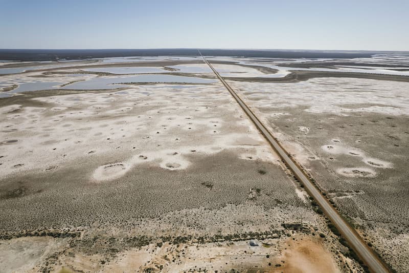
Salt Lakes
Lake Grace, Lake Bryde, Lake Biddy, Lake King. Geologically the Wheatbelt is an ancient stable area with a very low drainage profile. The rain that falls is very slow to drain away and is held in large shallow depressions. This leads to lots of evaporation and and the formation of lakes of salt. Unless the rainfall is very heavy over a number of seasons many of the salt lakes are dry for most of the year. Even in their dry state they offer stunning scenery and great photo opportunities.
Granite Outcrops
Dragon Rock, Dingo Rock, DIckman Rock, Namma Rock. Granite Outcrops are either inselbergs (isolated rock hills and knobs) or monoliths, (a single massive stone hill or rock). Erosion usually exposes these geological formations, which are often made out of very hard and solid metamorphic or igneous rock made from granite. Rising abruptly from the gently sloping or level surrounding plain they dominate the bushland.
John Holland Way
Follow in the steps of one of Western Australia’s early pioneer explorers and discover the riches of Western Australia’s Golden Outback Region.
Download more information and brochure here.
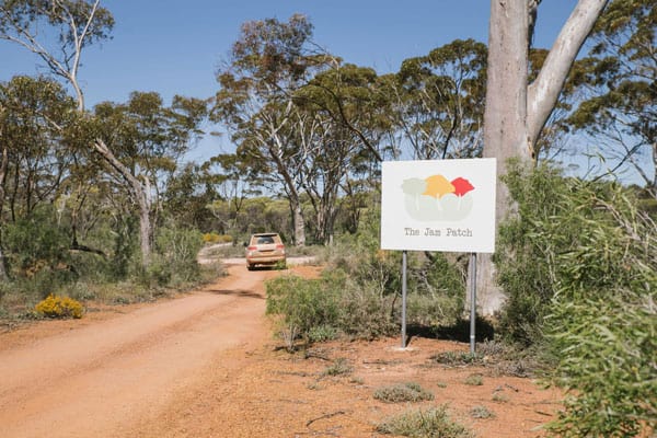
Jam Patch
Located North of Lake Grace, 19km from Lake Grace townsite, the Jam Patch is a nature reserve with walk trails, picnic and camping areas. Please note there is no water or power available at the site, however there is an eco toilet for public use. For more information, please contact the Lake Grace Visitor Centre 9865 2140.
Kwongan Heathland Walk
A new walk trail located 5km east of Lake Grace town – waiting for you to discover. The walk is through bushland with a well-marked trail and interpretive signage to familiarise you with flora you will find along the way. A well-loved wildflower hotspot.
For more information and a Kwongan Heathland Walk brochure/map call the Lake Grace Visitor Centre – contact 9865 2140.
Walker Lake – Walk Trails
Feeling energetic? If you’re staying in town, this is the perfect opportunity to see Narembeen nature at its best. Located to the south of the Narembeen townsite is a natural lake with abundant water in summer. Wander around the lake as you take in this majestic setting. The Walker Lake trail is 1.8km, for those more energetic walk the 2.2km Avoca Farm walk trail, enjoy the rural setting as you take in the old Avoca Homestead, Shearing Shed and machinery on display.
Hidden Hollow
Situated approximately 30kms east of Narembeen, along your Pathway to Wave Rock experience. Formally known as Mt Walker Rock, this is the perfect place for a picnic and to see many wildflowers and orchids during Spring (Sept to Dec). This granite outcrop also boasts a natural amphitheatre that has been carved out of the rock over years of weathering – it can be found walking from the car park along the trail. For the more energetic – the view from the summit offers spectacular views of the district. Take your time, read the plaques at the little dam and discover a piece of farming history.
Wakeman Ski Lake
Situated approximately 13kms east of the Narembeen townsite, this lake has undergone major volunteer work to harvest water back into the natural lake (water level is dependant upon seasonal rainfall). During the summer months, the lake is a hive of activity with ski boats and water pursuits popular with locals and visitors. This is a picturesque location, with abundant bird life. Before entering the lake with boats, please contact the Narembeen Community Resource Centre T: (08) 9064 7055 (business hours only) and provide boat insurance details.
Wadderin Wildlife Sanctuary
Wadderin Wildlife Sanctuary spans 400 hectares, enclosed by an 11km fence, providing a haven for rare or once-extinct fauna in the WA Wheatbelt region. Within this protected area, species like the Red-tailed Phascogale, Brush-tailed Bettong, and Malleefowl thrive, protected from invasive species by the fence. Managed by a local community group, ongoing maintenance and collaborations with scientists ensure the sanctuary’s success.
Information Centre and Walk Trail
The Wadderin Wildlife Information Centre and Walk Trails sit outside the fence. Explore the Mallee Fowl or Woylie walk trails for a gentle walk through the Eucalypt woodlands and Mallee shrublands, enjoy the 15th Green Picnic Area and experience the bed of wildflowers that come alive in spring. Interpretive signs will help you identify flora, fauna and birds. Trails WA for more information
Wadderin Wildlife Night Tours
Night tours are available to the public and are taken on an open electric bus so you can hear, see and experience the bush and the fauna that live there first-hand. For more information and to make a booking click here
Roe Dam
Located approximately 45km east of Narembeen is a 20 million gallon storage dam completed in 1971 which supplies the Mt Walker farming community. This is a bird watchers paradise! Take in the majestic eucalyptus with an under-story of bracken fern. Picnic area, toilets and BBQ’s are available in this tranquil setting. The friendly locals are often seen leaving piles of firewood.
Roe Lookout
Situated approximately 8kms from Narembeen and named after John Septimus Roe, Surveyor General who led an expedition eastwards from York in October 1836. A scenic drive takes you to the peak of this granite formation with magnificent panoramic views of the district – a photographer’s delight! There is limited vehicle access to the top of Roe Lookout, the steep incline is not suitable for caravans. Feel free to park at the bottom and take a leisurely walk to the top of the lookout.
For further information:- Narembeen Community Resource Centre T: (08) 9064 7055
E: [email protected]
Nookaminnie Rock Nature Reserve and Rowlie Mellor Walk Trails
527 hectares of unique remnant vegetation where you can enjoy some of the most beautiful wildflowers the Wheatbelt has to offer. At the heart of the Reserve you will find Nookaminnie Rock, a large granite outcrop with magnificent views, a perfect platform to watch the Wheatbelt’s breathtaking sunsets. A display board at the entrance to the Reserve outlines the marked walking trails. Pick up a copy of our Nature Reserve Map from the Quairading CRC and Visitor Centre.
Toapin Weir
An easy breezy 8 kilometres north (and slightly west) of the Quairading town site. Climb to the top of the rock with the assistance railing and take in the picturesque views of the region. Toilet facilities, electric BBQ, shade and info boards can all be found in the car park. It is also a quaint, quiet overnight camping spot with immaculate skies for pristine star gazing.
Pink Lake
Pink Lake is regarded as a local phenomena. It is located 11 kilometres east of town on the Bruce Rock road and at certain times of the year the left side of the lake is a distinctive pink colour while the right side remains blue. Summer evaporation causes the water level to drop and salt builds up on the old trees and fence posts. When the water returns, the salt causes the pink colour.
Lake Mears
This little known local gem is located partly within the Lake Mears Nature Reserve. Well worth a look, especially after heavy rainfall, to see it in all its glory at full capacity. There are no rubbish facilities here so please leave no trace and take your waste with you. Entry is off of Lake Mears Road.